|
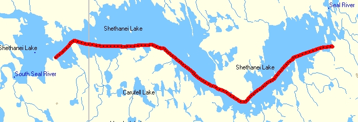
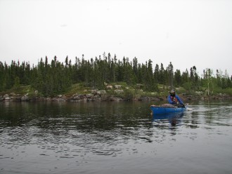
Day 17 Time: 10 hrs 55 min Distance: 32.1 km (245.3) I was up at 8:30, we prepared methodically, the skies were still grey but the wind while still present was greatly reduced. No doubt now, we are getting the hell out of here! By 10:20 we are on the water (somewhat of a record), the paddling requires effort but is not too taxing; we make steady progress jumping from target to target stopping at each for a few minutes. Hours & K's pass, the wind is diminishing even more. I'm seeing a few landmarks I recognize from '06. We make the turn southeast and then cross over to the opposite shore, a long paddle with a bit of a side wind, it's still a long way to the point which we have been considering as a campsite. Finally we can turn the corner but again it's not quite there. Things seem different, of course the water is high, the site I remember from '06 was obvious at this point, I edged around the tip of the peninsula, yes there it is/was, now fully underwater.
|
|
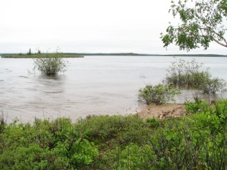
We stopped for lunch; there was enough space for that but not enough dry ground to pitch a tent. The alternate site around the corner did not look too appealing from a brief and distant look. We decided to go the extra 10 km (more like 11+) to Hap Wilson's marked site on the southeast shore close to the end of the lake. I figured an early bailout might be needed as we had already done our theoretical 6-hour daily average; my feeling was that in light of our pitiful average of 23 minutes per day over the past 3 days we needed to go the extra time. The first 2km stretch took a fair effort, there were a few whitecaps to deal with but they resulted from shallow water of sandbars rather than stronger wind. We hopped to the next island, a bit easier time and then set our sites on the ling point. This is where I thought our bailout camp in '06 was at the end of the point and it soon became clear that it was. In 2006 I was in group of 3 in 2 boats, shortly after leaving camp we encountered extremely strong wind, after a couple of hours of hard work we were forced to shore unable to continue without an insane risk of swamping, the solo canoe that was with us was blown 3 or 4 km's to the north shore, had to do an emergency bivy before rejoining us the following day when the weather improved. We stopped to check out the spot, in '06 we had camped below the rocks on the boulder beach, this is all well under water and the higher rocks offered no decent tent sites and nothing big enough for the hut.
|
|
The day has been long but the paddling conditions are now excellent if one ignores the threatening skies so we press on in spite of the late hour. Rounding the point I see in the distance an obvious sign of an open area, it will easily take an hour to reach but surely this is the site marked by HW. As we near it becomes apparent this "area" in not on the far shore, it is closer, it is an island of rocks, mainly two giant square boulders / blocks, useless for camping. Still further distant about 1 km is the sign of a small beach that must be where the site is. Immediately to our right is a rocky promontory, possible for a camp but from the water looks potentially lumpy and overgrown so we head for the beach.
|
|
|
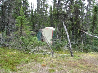
There is in fact some beach exposed here, perhaps even enough to pitch a small tent, we go up 6 feet and back 30 to a good flat spot in the trees. As we finish erecting the hut the rain begins, light at the start with some heavier showers to follow. We tried the Singapore Noodles & Chicken (backpackers Pantry) which was pretty good, too tired to bother having anything else and it's already Midnight. I wonder how we will do tomorrow; for sure we will be done with these lakes and into some moving water.
|